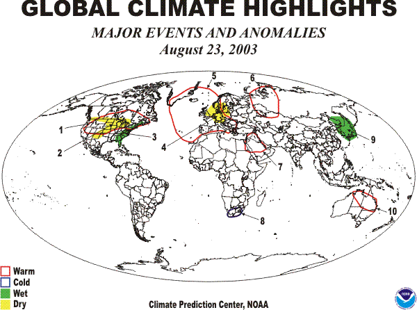
1. Northern North America:
HIGH TEMPERATURES CONTINUE
Temperatures averaged 2°C to 7°C above normal across much of the United States and southeastern Canada, with the highest departures (+5 to +12°C) reported across south central Canada and the north central United States. Highs soared into the forties and upper thirties (°C) in the northern and central Plains (52°N) [WARM - Up to 12 weeks].
2. Central United States and Southwestern Canada:
THUNDERSTORMS EASE DRYNESS IN CENTRAL PLAINS
Moderate to heavy rains (25 to 75 mm) brought relief to the dryness in the central Great Plains, but much of the remainder of the region received little or no rain. Precipitation totals since June 29 were less than 100 mm and were among the lowest 10% of the climatological distribution [DRY - Up to 9 weeks].
3. Eastern United States:
HEAVY RAINS SATURATE FLORIDA
Heavy to torrential rains (50 to 200 mm) inundated much of Florida, while scattered thunderstorms brought 25 to 100 mm of rain to parts of the remainder of the eastern United States. Since May 25, between 400 and 900 mm of rain produced 13-week moisture surpluses of 100 to 450 mm [WET - Up to 23 weeks].
4. Western Europe:
SCATTERED SHOWERS BRING SOME RELIEF
Scattered showers (20 to 70 mm) eased dryness in parts of Western Europe but little or no rain fell in the remainder of the area. During the last 13 weeks, precipitation totals ranged from 50 to 300 mm, yielding moisture deficits of 50 to 250 mm [DRY - Up to 13 weeks].
5. Western Europe:
HEAT ABATES
Weekly departures of up +2 to +6°C again covered Western Europe with departures up to +8°C in Austria. Highs, however, generally remained below 35 (°C) that were considerably less than the previous weeks [WARM - Up to 15 weeks].
6. Western Siberia:
WARMTH REMAINS
Weekly departures of +2°C to +8°C prevailed over western Asian Russia and adjacent portions of European Russia and northern Kazakhstan. Temperatures reached as high as 35°C at Turgay, Kazakhstan (50°N) [Warm - 4 weeks].
7. Middle East:
WARM ANOMALY CONTINUES
Temperatures were 2°C to 4°C above normal for the week from Syria southward into Saudi Arabia, with highs ranging from 33°C to 47°C. [WARM - 3 weeks].
8. Southern Africa:
COLD ANOMALY DEVELOPS
Weekly departures of -2°C to -7°C again prevailed over eastern Kazakhstan, but the mercury remained above freezing [COLD - 2 weeks].
9. East Central Asia:
WET AREA EXPANDS
Although parts of Japan received little or no rain, 25 to 80 mm of rain fell on the remainder of the islands. Very heavy to torrential rains (150 to 300 mm) inundated the Korean Peninsula, while moderate to heavy rains (25 to 100 mm) again soaked northeastern China. During the last four weeks, precipitation has totaled 150 to 600 mm over parts of Japan and northeastern China, which is 2 to 4 times the normal amount for this period [WET - Up to 5 weeks].
10. Eastern Australia:
WARM ANOMALY REMAINS
Temperatures averaging 2°C to 4°C above normal dominated northeastern Australia with highs reaching into low thirties and high twenties (°C) [WARM - 3 weeks].